The construction of the aqueduct, mosque and other buildings, as well as the refortification of Kavala (then still known as Christoupolis) appear to have been part of concentrated efforts to revive the city following its destruction and depopulation during battles for the control of the area between the Venetians and Turks in the previous century (see page 2: History of Kavala).
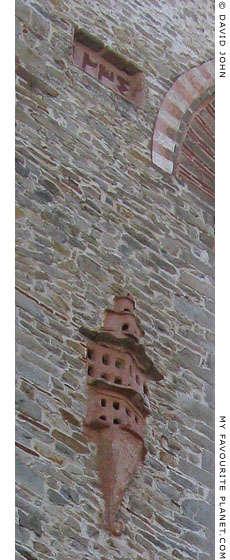
The aqueduct was well maintained, with only one major repair required in 1818. A Turkish inscription on the west side (see photo right) is dated "١٢٣٤", 1234 AH in the Muslim Hijri calendar, which corresponds to 1818/1819 AD in the Western Gregorian calendar. It remained in use until the early 20th century. Recent restoration work was undertaken in 1997-1998.
Built of local granite, with Ottoman style brickwork used in some of the arches, the aqueduct is 280 metres long, has a maximum height of 25 metres and a total of 60 arches (some sources say 270 metres long and 26 metres maximum height).
The structure comprises of two tiers of arches supporting the water channel. The bottom tier is thicker and the 11 arches are wider and higher (5.60 metres wide, 12 metres high) than the main arches of the upper tier (5 metres wide, 8 metres high), which are set directly above them. Between the upper tier's main arches each of the stone piers are pierced by two smaller arches, one directly on top of the other, the lower arch being wider and higher than the upper. Metal staves have been used to support some of these smaller arches.
The Kamares spans the lower ground between the foot of Mount Lekani (at the south end of Odos Lahana) and the old city walls on the northeast slope of the hill of the Panagia peninsula.
It was the last stage of a well-planned network of ceramic pipes and four other aqueducts which carried water to the city from the 400 metre high source, known as the "Mother of Water" (η μάνα του νερού, i Mana tou Nero; also known as ή Τρία Καραγάτσια, i tria Kragatsia, the Three Elms; and ή Σούμπαση, i Soumpasi, after the Turkish word for source), 6 km to the north. Water was also chanelled from other smaller sources nearby.
Some of the water was diverted to drinking fountains and troughs in the countryside along the way for travellers, farmers and their animals.
Within the citadel of Kavala, water was distributed by pipes to storage tanks, public fountains (of which the remains of three are still extant), baths and important buildings. The first house in Kavala to have running water was the House of Mehmet Ali, built around 1780-1790 (see gallery pages 21-22). |
|

The west side of the aqueduct,
south of Odos Pal. Idragogiou,
one of the roads eastwards out
of the town centre which pass
through the arches.
A Turkish inscription with the date
"١٢٣٤", 1234 AH (1818/1819 AD),
the time of repair works. Below
it is one of two dovecotes or
birdhouses built onto the wall. |