|
|
| My Favourite Planet > English > Middle East > Turkey > Kuşadası |
| Kuşadası, Turkey |
Practical information for Kuşadası |
|
 |
page 3 |
 |
|
| |

The covered bazaar at the harbour in the old town of Kuşadası |
Kuşadası
Turkey |
Facts & figures |
|
| name: |
Kuşadası (pronounced koo-shá-dah-suh),
Turkish for Bird Island
|
| region: |
Aegean (Turkish, Ege Bölgesi), western Anatolia
Regional capital: Izmir
|
| province: |
Kuşadası is one of the 17 districts of Aydın province.
Provincial capital: Aydın
|
| location: |
Kuşadası is on a broad bay of the eastern Aegean sea, north of the Dilek peninsula (Dilek Yarımadası, ancient Mykale), and northeast of the Greek island of Samos. The mountain Pilav Daği rises to the east of the town.
It is 95 km (59 miles) south of the regional capital Izmir;
18 km (11 miles) southwest of Selçuk (near Ephesus);
and 71 km (44 miles) west of the provincial capital Aydın.
The narrow coastal strip to the north and south of Kuşadası is built up, with housing estates, hotels and holiday homes. Agriculture is carried out among the hills to the east of the town.
In ancient times this area was part of Ionia.
|
| area: |
(district) 224.60 square kilometres (86.72 square miles)
|
| population: |
Urban 70,143; District 90,652 (2012)
During the summer the population rises to around half a million, including Turkish and foreign visitors and seasonal workers in the tourist and associated industries. Many foreign residents, mostly from Europe, also live in the area.
|
| language: |
Turkish
|
| local time: |
Eastern European Time (EET)
Daylight Saving Schedule:
Summer (from last Sunday in March) GMT/UTC +3 hours
Winter (from last Sunday in October) GMT/UTC +2 hours
|
| currency: |
Turkish Lira (TRY or TL)
|
| climate: |
Mediterranean
|
| post code: |
09400
|
| telephone code: |
+90 256
|
| website: |
www.kusadasi.bel.tr (Turkish and English) |
Further information for Turkey, including visa details,
can be found in our introduction to Turkey. |
|
| |
| |
Kuşadası
Turkey |
Local addresses & telephone numbers |
|
 |
|
Kuşadası Tourist Information Office
Liman Caddesi 13 (at the harbour)
June - September daily 8am-5 pm;
October - May Mon-Fri 8am-5pm
Free street maps and accommodation information.
Tel: (0256) 614 11 03 e-mail: turizm@kusadasi.gov.tr |
|
| |
Kuşadası
Turkey |
Area map |
|
 |
|

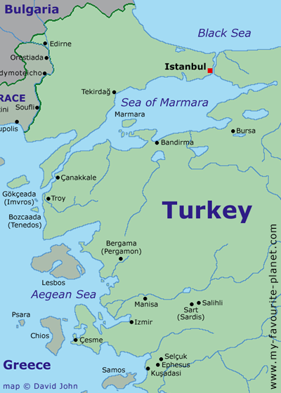
Map of north-western Turkey and the Aegean area.
See a larger interactive map of this area. |
|

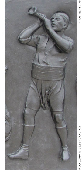
Bronze relief of a local man in
traditional costume playing a zurna.
Part of a frieze at Kuşadası harbour. |
|
Map, photos and articles: © David John,
except where otherwise specified.
Additional photos: © Konstanze Gundudis
All photos and articles are copyright protected.
Images and materials by other authors
have been attributed where applicable.
Please do not use these photos or articles without permission.
If you are interested in using any of the photos for your website,
project or publication, please get in contact.
Higher resolution versions are available on request.
Some of the information and photos in this guide to Kuşadası
originally appeared in 2004 on davidjohnberlin.de. |
|
| |
 |
Visit the My Favourite Planet Group on Facebook.
Join the group, write a message or comment,
post photos and videos, start a discussion... |
|
|
| |