|
|
|
| My Favourite Planet > English > Europe > Greece > Dodecanese |
| Greece |
Introduction to the Dodecanese islands |
|
|
| |

Panoramic view over Skala, the main port of the Dodecanses island of Patmos. |
| |
|
| |
The Dodecanese archipelago, in the southeastern Aegean Sea, is the easternmost group of Greek islands, some of which are just a few kilometres from the west coast of Turkey.
Although the name Δωδεκάνησα means "the twelve islands", there are actually over 160, ranging from Rhodes, the largest and most important, to tiny uninhabited islets such as Stroggyli, near Kastellorizo.
These days it is relatively easy to visit many of the islands by plane or ferry, but historically they were quite remote from the mainland and from each other. This remoteness, as well as the dry climate, mountainous terrain and poor soil on many of the islands, forced the inhabitants to become seafarers - merchants, fishermen and sponge divers.
Conquered and settled in ancient times by many peoples, including Minoans, Carians, Mycenaean and Doric Greeks and Romans, in more recent times dominance over the islands was contested between the Byzantine Empire, Crusaders, Ottoman Turks, Venetians and Genoese.
The islands gained independence from the Ottoman Turks in 1912 and formed the Federation of the Dodecanese Islands. However they were occupied by Italy soon after, and only became part of the modern Greek state after the Second World War.
Several of the islands have a distinctly Dodecanese culture, most obviously apparent from the architecture of its old houses and churches, local cuisine and unique features such as choklakia mosaics. Other cultural traditions, such as local costumes, dialects, music and dances, are becoming less easy to find, except in folklore museums and at special events. The Italian occupation, during which the Greek language was forbidden, also had an effect on local culture.
Beyond the crowds of the main towns and tourist centres such as Rhodes town, life is quite relaxed and easy-going. For those who wish to explore, there are plenty of places of natural beauty, uncrowded beaches and historical sights. |
| |
Dodecanese
islands |
Facts & figures |
|
 |
| name: |
Dodecanese (Greek, Δωδεκάνησα, literally the twelve islands)
|
| capital: |
Rhodes
|
| location: |
The Dodecanese consists of 12 larger islands and over 150 smaller islands and islets in the southeastern Aegean, close to Turkey's Western Anatolian coast. Many of the islands can therefore be considered to belong geographically to Asia, though ethnically and culturally all are very decidedly Greek.
|
| islands: |
By far the largest island is Rhodes, which also has the largest population and attracts the most tourists.
26 of the islands are nominally inhabited, although on some of the smaller islands the only inhabitants are soldiers who are stationed temporarily there.
The inhabited islands, in order of size:
Rhodes, Karpathos, Kos, Kalymnos, Astypalea, Kasos, Tilos, Symi, Leros, Nisyros, Patmos, Chalki, Lipsi, Pserimos, Agathonisi, Levithia, Megisti (Kastellorizo), Arki, Kinaros, Marathi
|
| periphery: |
(administrative region) Southern Aegean islands
(Greek, Περιφέρεια Νοτίου Αιγαίου)
The semi-autonomous region consists of the Cyclades and Dodecanese island groups in the central and southeastern Aegean Sea, and is divided into 13 regional units:
Andros, Kalymnos, Karpathos, Kea-Kythnos, Kos, Milos, Mykonos, Naxos, Paros, Rhodes, Syros, Thira (Santorini), Tinos
Capital: Ermoupoli, on the island of Syros.
For further information about Greece's
administrative divisions see our page:
Greece facts and figures.
|
| population: |
200,452 (2005)
|
| area: |
2,714 square km
|
| local time: |
Eastern European Time (EET)
Daylight Saving Schedule:
Summer (from last Sunday in March) GMT/UTC +3 hours
Winter (from last Sunday in October) GMT/UTC +2 hours
|
| currency: |
Euro (€)
|
| climate: |
Mediterranean (temperate, with wet winters
and hot, dry summers)
|
| language: |
Greek |
Further information for Greece can be found
in our introduction to Greece pages. |
|
| |
| |
Dodecanese
islands |
Area Maps |
|
 |
|

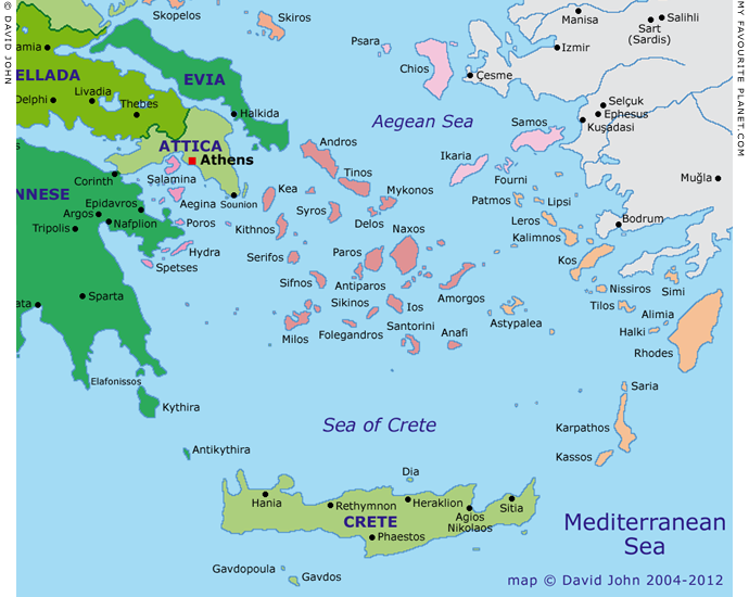
Map of the Dodecanese and the Southern Aegean
Colour key for Greek island groups (west-east)
| |
|
Argo-Saronic |
|
|
|
Sporades |
|
|
|
Cyclades |
|
|
|
Northern Aegean |
|
|
|
Dodecanese |
See also our interactive map of Greece. |
| |

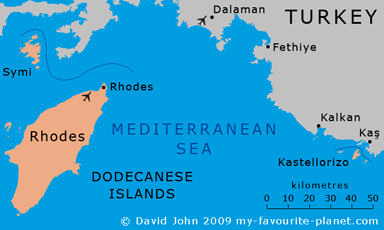
Map showing the position of the remotest Dodecanese island
Kastellorizo in relation to Rhodes and the Lycian coast of Turkey.
See larger maps of Kastellorizo, including a detailed map of the island. |
Articles, maps and photos: © David John,
except where otherwise specified.
Some of the information and photos in this guide originally
appeared in 2004-2005 on davidjohnberlin.de.
All photos and articles are copyright protected.
Images and materials by other authors
have been attributed where applicable.
Please do not use these photos or articles without permission.
If you are interested in using any of the photos for your website,
project or publication, please get in contact.
Higher resolution versions are available on request.
My Favourite Planet makes great efforts to provide comprehensive and accurate information across this website. However, we can take no responsibility for inaccuracies or changes made by providers of services mentioned on these pages. |
|
| |
 |
Visit the My Favourite Planet Group on Facebook.
Join the group, write a message or comment,
post photos and videos, start a discussion... |
|
 |
| |
|
|
| |
| |
Olive Garden Restaurant
Kastellorizo,
Greece
+30 22460 49 109
kastellorizo.de
|
| |
Papoutsis
Travel Agency
Kastellorizo,
Greece
+30 22460 49 286
greeklodgings.gr
|
| |
 |
| |
 |
| |
 |
| |
 |
| |
 |
| |
 |
| |
George Alvanos
rooms in
Kavala's historic Panagia District
Anthemiou 35,
Kavala, Greece
kavalarooms.gr
|
| |
|