|
|
|
| My Favourite Planet > English > Europe > Greece > Thrace |
| Thrace, Greece |
Introduction to Thrace |
|
 |
page 1 |
 |
|
| |

The centre of Didymoteicho, on the Erythropotamos River, northeastern Thrace. |
| |
|
| |
Since 1987 the small, remote region of Thrace (also referred to as Western Thrace), in the northeast of Greece, has been part of the administrative region of East Macedonia and Thrace, itself part of the large semi-autonomous region of Macedonia.
My Favourite Planet guides to places in Thrace are in a separate section rather than as part of the guides to Macedonia. Similarly, some islands, such as Samothraki, which are now also politically part of Macedonia and Thrace, appear in our section on the North Aegean Islands. We think this makes more sense for travellers who may be more interested in the particular character and flavour of an area or island than immediate political concerns.
Mainland Thrace is a long strip of coastal plain along the Thracian Sea, part of the North Aegean Sea. In the west the land rises north to the wild Rhodope Mountains which form a natural frontier with southern Bulgaria. In the east the valley of the Evros River descends from the borders between Bulgaria, Turkey and Greece, southwards through extensive farmlands to the wide delta on the coast, west of the Gallipoli Peninsula and the Dardanelles.
There is very little tourism in the region, and most Thracians make their living from agriculture, mainly wheat and tobacco. There are only six towns of any size, the port and transportation hub of Alexandroupoli being by far the busiest. Many villages are quite isolated, while others, particularly along the main roads and along the Evros valley, are well connected to the towns.
The recent road-building projects in the region, especially the new A2 (E90) "Egnatia Odos" motorway across northern Greece, has made travelling around much easier, and improved life for local people: previously many roads were impassable in winter and villages cut off. On the other hand the Greek economic crisis has seriously affected public transport, including rises in fares and reductions of ferry and train services.
There are no glittering cities, idyllic beaches, breathtaking scenery, spectacular historic sites, monuments or museums here (the main archaeological museum is at Komotini; see Museums in and around Alexandroupoli). The landscapes and sights are modestly impressive and the towns are agricultural market centres. However, life is relatively relaxed, the people are friendly and the ethnic mix of Greeks, Turks and Pomaks, especially in the villages, is almost unique in the Balkans. Many local traditions, for example music and dance, still survive and can be enjoyed on feast days and at local fairs (see photos below). Recent events here have inlcuded bagpipe festivals.
For nature lovers and hikers there are large areas of wild, wooded and hills and mountains, with many species of birds and animals, as well as the nature reserve of the Evros Delta National Park. |
|
 |
| |

The symbol of
East Macedonia
and Thrace |
| |
|
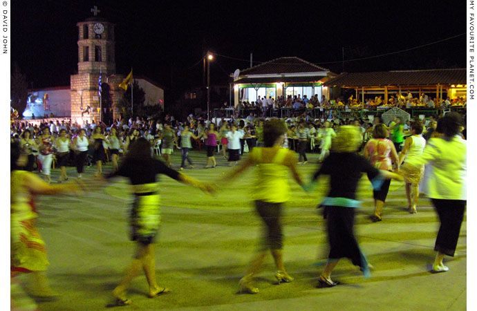
Thracian women dancing on a large public square in Orestiada, northeastern Thrace,
during celebrations of the Assumption of the Virgin Mary on 15th August 2008.
For further information about the Assumption of the
Virgin Mary in Greece, see Kavala gallery page 20. |
| |
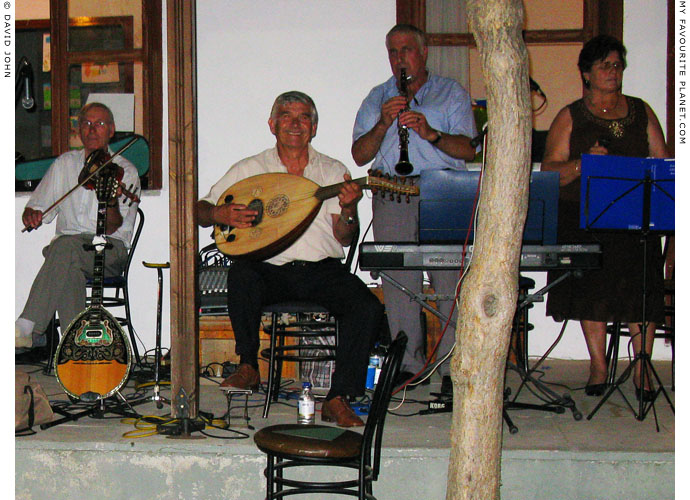
Seasoned Thracian musicians playing at a local festival. In some cases modern musical instruments
take the place of traditional. Here the violin stands in for the lyra and the clarinet for the zurna.
See also photos of Macedonian musicians and dancers in Thessaloniki
and Turkish musicians and dancers in Istanbul at The Cheshire Cat Blog. |
| |
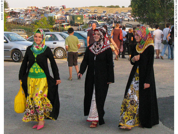
Young Muslim women at a country fair in the village of Megalo Dereio (Μεγάλο Δέρειο)
in the foothills of the Rhodope Mountains, west of the Evros River, northern Thrace.
Many of the villages of Thrace are inhabited by Turks, Bulgarian-speaking Pomaks and Muslim Roma. |
| |
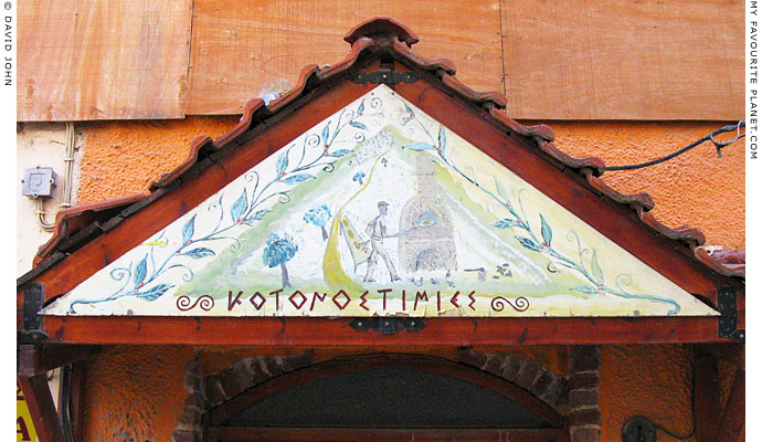
A hand-painted bakery sign in Didymoteicho, northeastern Thrace./td> |
| |
Thrace,
Greece |
Thrace facts and figures |
|
 |
|
| name: |
Thrace (Greek, Θράκη, Thraki)
Also referred to as West Thrace
|
|
| location: |
Southern Europe, on the Balkan peninsula, bordering the Northern Aegean Sea
in the south, Bulgaria in the north and Turkey in the east.
|
| region: |
East Macedonia and Thrace
(Greek, Ανατολική Μακεδονία και Θράκη, Anatoliki Makedonia kai Thraki)
www.pamth.gov.gr
One of the 3 regions of the Greek semi-autonomous
administrative Region of Macedonia.
|
| capital: |
Capital of East Macedonia and Thrace: Kavala, Macedonia
Main city of Thrace: Komotiní (Κομοτηνή), capital of the Rhodope regional unit
|
| regional units: |
Xanthi (Ξάνθη), Rhodope (Ροδόπη), Evros (Έβρος)
See details of the regional units of East Macedonia and Thrace
on Facts and figures for Macedonia, Greece.
|
| towns / cities: |
Alexandroupoli (Αλεξανδρούπολη), population 72,959
Didymoteicho (Διδυμοτείχο), population 19,493
Komotini (Κομοτηνή), population 66,580
Orestiada (Ορεστιάδα), population 37,695
Soufli (Σουφλί), population 14,941
Xanthi (Ξάνθη), population 55,360
The region of East Macedonia and Thrace also includes the island of Samothraki.
|
| local time: |
Eastern European Time (EET)
Daylight Saving Schedule:
Summer (from last Sunday in March)
GMT/UTC +3 hours
Winter (from last Sunday in October)
GMT/UTC +2 hours
|
| climate: |
Mediterranean (temperate, with wet winters and hot, dry summers);
continental (wetter, cooler) in the north.
|
| language: |
Greek
Minorities in Thrace include: an estimated 100,000 Muslims, mostly Turks;
around 39,000 Bulgarian-speaking Pomaks; several thousand Roma,
many of whom are Muslim.
|
| area: |
East Macedonia and Thrace: 14,157.76 square km (5,466.34 square miles)
|
| highest point: |
The peak of Haidou (Χαϊντού; also known as Erymanthos, Ερύμανθος),
1,827 metres, in the Koula mountain range (Κούλα Ροδόπης), in the
Rhodope Mountains, north of Xanthi.
|
| population: |
East Macedonia and Thrace: 608,182
|
| currency: |
Euro (€) |
| Further information for Greece can be found in our introduction to Greece pages. |
|
Thrace,
Greece |
Area map |
|
 |
|
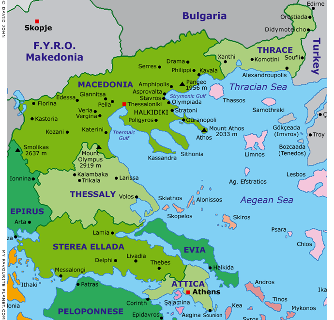
Interactive map of Macedonia, Thrace, Central Greece and the Aegean.
Colour key for Greek island groups (west-east)
| |
|
Argo-Saronic |
|
|
|
Sporades |
|
|
|
Cyclades |
|
|
|
Northern Aegean |
|
|
|
Dodecanese |
See also our interactive map of Greece. |
Photos, maps and articles: © David John,
except where otherwise specified.
All photos and articles are copyright protected.
Images and materials by other authors
have been attributed where applicable.
Please do not use these photos or articles without permission.
If you are interested in using any of the photos for your website,
project or publication, please get in contact.
Higher resolution versions are available on request.
My Favourite Planet makes great efforts to provide
comprehensive and accurate information across this website.
However, we can take no responsibility for inaccuracies or changes
made by providers of services mentioned on these pages. |
| |
 |
Visit the My Favourite Planet Group on Facebook.
Join the group, write a message or comment,
post photos and videos, start a discussion... |
|
|
| |
|
|
| |
| |
 |
| |
 |
| |
George Alvanos
rooms in
Kavala's historic Panagia District
Anthemiou 35,
Kavala, Greece
kavalarooms.gr
|
| |
 |
| |
 |
| |
 |
| |
 |
| |
Olive Garden Restaurant
Kastellorizo,
Greece
+30 22460 49 109
kastellorizo.de
|
| |
Papoutsis
Travel Agency
Kastellorizo,
Greece
+30 22460 49 286
greeklodgings.gr
|
| |
|