My Favourite Planet - the online travel guide
 
Greece
 
  1 introduction
2 geography
3 history
4 facts & figures
5 interactive maps
6 index of places
 
My Favourite
Planet guides
 
  contents
contributors
impressum
sitemap
 
 
Places in
Greece
 
  Agios Efstratios
Alexandroupoli
Athens
Kastellorizo
Kavala
Patmos
Pella
Polygyros
Psara
Samos
Samothraki
Stageira &
Olympiada
Veria
 
Places on My Favourite Planet
England
  Avebury
Turkey
  Istanbul
Ephesus
Kuşadası
Selçuk
Pergamon
 
MFP People
 
My Favourite
Planet Blogs
 

The Cheshire Cat Blog - travel articles, photo essays and videos at My Favourite Planet Blogs

Cheshire Cat
Blog
 

Edwin Drood's Column - the blog by The Mysterious Edwin Drood at My Favourite Planet Blogs

Edwin Drood's
Column


Guide to Planet Earth at My Favourite Planet

Guide to
Planet Earth
Visit the My Favourite Planet Group page on Facebook
  My Favourite Planet, the online travel guide  
home   places   galleries   news   about   contribute   contact   blogs
My Favourite Planet > English > Europe > Greece
Greece Geography of Greece page 2
 
Athens, Greece at My Favourite Planet

Greece lies at the southern end of the chain of mountains which form the Balkan peninsula. The mountains forming the Greek mainland tumble into the Mediterranean and reappear here and there as islands. Many of the over 2000 islands (some estimate as many as 6000) are merely barren rocks and only 227 are populated. The largest, Crete is potentially self-sufficient in terms of food and water, while others sometimes have to ration water or import it by tanker.

Greece is bordered to the north by Albania, the Republic of North Macedoniathe (formerly part of Yugoslavia), Bulgaria and to the northeast by Turkey. To the west lies the Ionian Sea and to the east the Aegean Sea.

Other branches of the Mediterranen around Greece include the Thracian Sea and the Sea of Crete.

Greece's geography and climate are well suited to a wide variety of farm produce including: olives, grapes, citrus fruit, tobacco and wheat.
 
 
See also The Cheshire Cat Blog
photo essays about Greece:
 
Athens
(street life)

Athens
(Aristotle's Lyceum)

Dion

Meteora
  Pella

Thessaloniki

Polygyros

Kastellorizo
(Megisti)
 
 
Map of Greece at My Favourite Planet

Map of Greece

See also our larger interactive map of Greece.
national Greek flag at My Favourite Planet

Greece

photo galleries
 

Athens photo galleries at My Favourite Planet

Athens

Kastellorizo photo gallery at My Favourite Planet

Kastellorizo

Kavala photo gallery at My Favourite Planet

Kavala

Photo gallery of Olympiada village, Halkidiki, Macedonia, Greece at My Favourite Planet

Olympiada

Patmos photo gallery at My Favourite Planet

Patmos

Pella photo gallery at My Favourite Planet

Pella

Polygyros photo gallery at My Favourite Planet

Polygyros

Samos photo gallery at My Favourite Planet

Samos

Samothraki photo gallery at My Favourite Planet

Samothraki

Photo gallery of Ancient Stageira, Halkidiki, Macedonia, Greece at My Favourite Planet

Ancient Stageira

Veria photo gallery at My Favourite Planet

Veria
 

Hellenic Seaways Flying Dolphin 18 hydrofoil from Piraeus entering the main harbour of Aegina, Greece at My Favourite Planet

Hellenic Seaways "Flying Dolphin 18" hydrofoil passenger ferry
from Piraeus entering the main harbour on the island of Aegina.
 

Aegean Flying Dolphin Athina hydrofoil en route to Piraeus from Aegina at My Favourite Planet

Aegean Flying Dolphins "Flying Dolphin Athina" hydrofoil passenger ferry
off the northwest coast of Aegina en route to Piraeus. This fast ferry
connects Piraeus with Aehina and its smaller neighbouring island Agistri.
 
Interactive map of Central Greece, Macedonia and the North Aegean Sea at My Favourite Planet

Interactive map of Central Greece, Macedonia and the North Aegean Sea.

See also our interactive map of Greece.


Vyzantino Greek Restaurant, Plaka, Athens, Greece
 
NEWGEN Travel Agency, Athens, Greece
 
Hotel Orestias Kastorias Thessaloniki, Greece - The heart of hospitality beats at the heart of the city
 
Hotel Liotopi, Olympiada, Halkidiki, Macedonia, Greece
 
Hotel Germany, Olympiada, Halkidiki, Macedonia, Greece
 
Hotel Okeanis, Kavala, Macedonia, Greece
 

George Alvanos

rooms in
Kavala's historic Panagia District

Anthemiou 35,
Kavala, Greece

kavalarooms.gr


Olive Garden Restaurant

Kastellorizo,
Greece

+30 22460 49 109

kastellorizo.de


Papoutsis
Travel Agency

Kastellorizo,
Greece

+30 22460 49 286

greeklodgings.gr


The Isthmus at Corinth, Greece at My Favourite Planet

The panoramic view eastwards from the top of Acrocorinth across the Isthmus at Corinth.
To the left (north) the modern city of Corinth on the south coast of the Corinthian Gulf.
To the right (south) the north coast of the Saronic Gulf.

The central mainland of Greece is joined to the southern peninsula of the Peloponnese (Island of Pelops) by a six kilometre wide strip of land known as the Isthmus, just east of Corinth. To its north is the Corinthian Gulf that opens out into the Ionian Sea to the west of Patras. To its south the Saronic Gulf (Σαρωνικός κόλπος) leads southwards to the Aegean Sea, peppered along the way with islands large and small, known as the Argo-Saronic islands, including Salamina (Salamis), Aegina and Poros.

In Antiquity Corinth grew rich and powerful mainly because it controlled the land route over the Isthmus. Corinthia, the city state's surrounding land, extended across the coasts on both gulfs and its two ports for warships and merchant vessels ensured military and commercial dominance of surrounding waters. Its fortified acropolis, the enormous 575 metre high Acrocorinth, provided views far in all directions. The photo above was taken from the highest of its two summits at the northeast of the bastion, on which visitors can still see the ruins of the infamous temple of Aphrodite.

Ships' captains who wanted to save the several days sailing around the Peloponnese had to pay to have their ships hauled over the Isthmus from one gulf to the other along a paved way known as the Diolkos. Rich and powerful people, including the Roman emperor Nero and the fabulously wealthy Athenian Herodes Atticus, dreamed of building a canal across the Isthmus. Although Nero began the building of a canal with an army of slaves, including Jewish captives sent by Vespasian. The modern Corinthian Canal was dug 1881-1893 and opened in 1893 (see below). The Peloponnese is now also joined to the rest of Greece by the Rio Bridge, further west along the Corinthian Gulf, near Patras.

Theoretically, from up here it is possible to see as far as Athens and beyond, and, it is said, even the Athens Acropolis is visible, presumably with a powerful enough telescope or zoom lens. In practice this is usually impossible due to constant haze (especially in summer) and environmental pollution.
 

The Corinth Canal from Isthmia, Greece at My Favourite Planet

The southern end of the Corinth Canal at Isthmia.

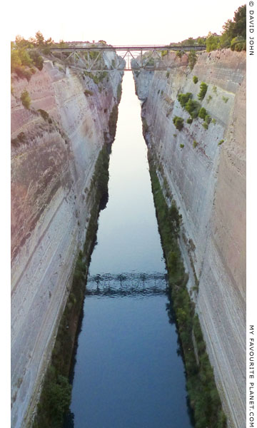
Although it was not quite as vast an undertaking as the contemporary construction of the Suez Canal, the building of the Corinth Canal was no mean feat of engineering, particularly for the 19th century, when newly-independent Greece was still a small, poor and embattled country. In just 12 years its builders dug an artificial gorge, 6.3 kilometre long, 87 metre deep and 24.6 metres wide, through solid limestone, north to south, to join the Corinthian Gulf to the Saronic Gulf.

Above its 79 metre high cliffs, the canal is spanned by bridges for the motorway, the old Corinth to Athens road and the railway, as well as the inevitable power and telephone cables.

The photo above was taken from a submersible road bridge across the southern end of the canal at Isthmia, itself an engineering wonder, which is lowered to the sea bed around every half hour to allow ships to pass. Today, in the age of super tankers, giant container ships and mega cruise liners, most of the traffic along the waterway consists of smaller cargo ships, tour boats and private craft. At either side of the bridge is a restaurant with a terrace where you can sit and watch the bridge rise and fall and the passing boats and ships.

About 10 minutes walk west of the bridge is ancient Isthmia, location of the Panhellenic Isthmian Games, a temple of Poseidon and a massive defensive wall. Visible remains at the archaeological site are negligible, but the small Isthmia Archaeological Museum is well worth a visit (Tuesday-Sunday, 8 am - 3 pm; closed Monday). Further south is the more impressive and atmospheric site of Nemea, the home of the ancient Nemean Panhellenic Games, and where Herakles is said to have fought the Nemean Lion. It also has an excellent small museum (same opening hours as Isthmia). There are only a couple of buses a day to Isthmia and Nemea from the centre of New Corinth, and none from ancient Corinth. If you do not have your own transport, you may consider it worthwhile taking taxis.

A rough, sometimes steep and overgrown footpath allows pedestrians to walk along the west side of the canal (on the left in the photo above) from Isthmia at least as far as the first bridge. A pleasant walk. From there, a road leads to the area of the Corinth/Isthmia inter-city bus station, where there are cafes, supermarkets and tourist shops. There is even a bungy-jumping platform (www.zulubungy.com).

A monument to the builders of the canal, in the form of of two enormous stone steles inscribed in Greek, Hungarian and English, was set up in 2009 at the side of the Corinth to Athens road near the northern end of the canal.

The inscription on the first stele:

"In grateful memory of the Hungarians István Türr (1825-1908) and Béla Gerster (1850-1923) who planned, organized and directed the construction of the Corinth Canal, a masterpiece of 19th century engineering.

The successful undertaking stands as a permanent monument to Greek-Hungarian relations and as inspiration to all future generations.

With great honour and respect to those who participated in the construction from 1881 to 1893."

The second stele states the canal's statistics:

"Built 1881-1893.
Length 6,343 metres.
Depth of channel 8 metres.
Width at sea level 24.60 metres. Bottom width 21 metres.
Inclination of the walls 71-77 degrees.
Height of the walls from sea level 79 metres.
Transits annually 12,500.

Grand opening ceremony: August 6, 1893, in the presence of King George I of Greece and Francis Joseph, Emperor of Austia and King of Hungary.
Open to traffic: August 28, 1893.
The canal reduced the distance between the ports of the Aegean and the Adriatic Sea by 131 nautical miles.

The monument was erected by: Republic of Hungary, Periandros S.A., Corinth Canal S.A., Municipality of Louraki, Perachora."
 

The northern end of the Corinth Canal at My Favourite Planet

The northern end of the Corinth Canal from
the bridge of the Corinth-Athens road.
Text, map and photos: © David John,
except where otherwise specified.

Some of the information and photos in this guide to Greece
originally appeared in 2003-2005 on davidjohnberlin.de.

All photos and articles are copyright protected.

Images and materials by other authors
have been attributed where applicable.

Please do not use these photos or articles without permission.

If you are interested in using any of the photos for your website,
project or publication, please get in contact.

Higher resolution versions are available on request.

My Favourite Planet makes great efforts to provide comprehensive and accurate information across this website. However, we can take no responsibility for inaccuracies or changes made by providers of services mentioned on these pages.
 
 
See also
The Cheshire Cat Blog
photo essays about Greece:

Athens (street life)

Athens (Aristotle's Lyceum)

Dion

Meteora

Pella

Thessaloniki

Polygyros

Kastellorizo (Megisti)
 
My Favourite Planet Group page on Facebook

Visit the My Favourite Planet Group on Facebook.

Join the group, write a message or comment,
post photos and videos, start a discussion...
< page 1: introduction to Greece page 3: history of Greece >
 
Copyright © 2003-2022 My Favourite Planet  |  contributors  |  impressum  |  contents  |  sitemap
my-favourite-planet.com   website design by Ursa Major Design
My Favourite Planet travel guide to Pella, Macedonia, Greece My Favourite Planet travel guide to Veria, Macedonia, Greece My Favourite Planet travel guide to Kavala, Macedonia, Greece Guide to Alexandroupoli, Thrace, Greece at My Favourite Planet My Favourite Planet travel guide to Samothraki island, Greece My Favourite Planet travel guide to Athens, Greece My Favourite Planet travel guide to Stageira and Olympiada, Halkidiki, Macedonia, Greece My Favourite Planet travel guide to Polygyros, Halkidiki, Macedonia, GreeceMy Favourite Planet travel guide to Agios Efstratios island, Greece My Favourite Planet travel guide to Psara island, Greece