|
The steep, rugged mountain range Samsun Daği (Samson's Mountain) dominates the view to the southeast of Samos. The range, with its highest point at 1,237 metres above sea level, forms the backbone of the Dilek Yarımadası (Dilek Peninsula). In ancient times both mountain and peninsula were known as Mykale (Greek, Μυκάλη).
Samos is separated from the Dilek Peninsula by the Samos Strait (Στενό Σάμου, Steno Samou) [1], which is only 1.6 km wide at its narrowest point, Cape Koukouras (Άκρα Κούκουρας), 8.5 km east of Pythagorio, as the crow flies.
The strait was the scene of two historical battles, the Battle of Mykale in 479 BC, when the Greeks defeated the Persians, and the naval Battle of Samos in 1824, during the Greek War of Independence (see gallery page 13).
On the Turkish side of the strait, the countryside, coast and beaches between Kuşadası and the Dilek National Park (Dilek Yarımadası Milli Parkı, known locally as Milli Parkı) are famed for being the most beautiful in Ionia.
The islet visible on the left of the photo is known as Bayrak Adasi, which means Flag Island, named so presumably because the Turkish flag flies there permanently. Although part of the Dilek National Park, the tiny island has a lighthouse and a large house. It is only around 700 metres from the Samos coast, making it the closest place in the Aegean between Turkey and Greece.
In 2012 the Turkish government rejected an application to place a GSM telephone mast on the island on the grounds that it would affect the island's ecology. Although this seems laudible, the ecology consists of a few wild plants and seagulls nests.
The sparce remains of Ancient Panionion (see below), the meeting place of the Greek Ionian cities, lie on the lower slopes of the mountain's northwest side, facing Samos. On the other side are the more substantial ruins of the once powerful city of Priene (see below).
In summer (April - October) there are daily ferries from Vathy (Samos town) and Pythagorio to the Turkish seaside resort Kuşadası. See How to get to Kuşadası, Turkey for further details.
A day return to Kuşadası should give you enough time to visit the fascinating remains of the ancient Greek city Ephesus which is 18 km (11 miles) northeast. More ambitious exploration of Turkey's Ionian coast (for example Priene, Miletus and Didyma) will take longer.
If you are travelling from Greece to Turkey you may need to buy a visa. See our introduction to Turkey for further information. |
|
photos & articles:
© David John |
|
| |

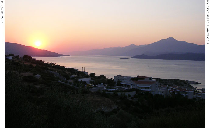
Sunrise on the narrow Samos Strait between the southeast coast of Samos
and the Dilek Peninsula, Turkey.
This photo and the one above were taken from Mykale Bay, east of Pythagorio.
On the left the southern slope of Mount Syrachos (Σύρραχος) descends to the sea
at Cape Katsouni (Άκρα Κατσούνι), near the village Psili Ammos (Ψιλή Άμμος),
and just beyond is Cape Koukouras (Άκρα Κούκουρας), the closest point
to the Turkish coast. On the right is Samsun Daği (Mount Mykale). |
| |

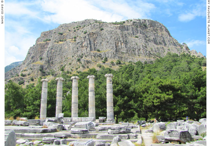
The rock of the Priene Acropolis on the other side of Mount Mykale, on the
eastern side of the Dilek Peninsula. In the foreground are the ruins of the
temple of Athena Polias, dedicated by Alexander the Great in 334 BC.
The ancient city of Priene (Πριήνη; today near the Turkish village of Güllübahçe), like Samos,
was one of the twelve cities of the Ionian League. Its impressive remains can be visited today
on the lower slopes of the northeast side of Mount Mykale (Μυκάλη). Priene's 381 metre high
acropolis sits on top of the huge rock, part of the mountain range, which towers above the city. |
| |

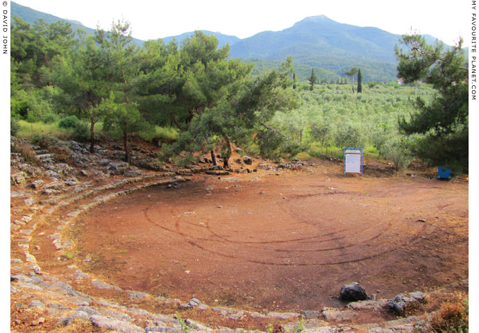
The remains of the ancient theatre at Güzelçamlı, on the west side of Samsun Daği (Mount Mykale).
|
This site on Otomatik Tepe (Machine Gun Hill), just outside the seaside village of Güzelçamlı, at the foot of Mount Mykale opposite Samos, is thought to be ancient Panionion (Πανιώνιον). The sanctuary of Poseidon Helikonios, controlled by Priene, was the meeting place of the cities of the Ionian League [2] and the location of the Panionia religious festival and games (πανήγυρις, panegyris, gathering, assembly).
Until 1920s Güzelçamlı was a Greek village known as Giaur-Changlee (also referred to as Changli or Tshangli, and in Turkish as Rumçamlısı) [3]. An ancient inscription referring to Panionion, seen on the wall of the Church of the Panagia (Virgin Mary) in 1673, was reported by the English traveller George Wheler [4]. Wheler presumed that the ancient name of the place was Panionion and subsequent scholarly visitors to the area agreed with this theory.
The site was rediscovered in 1898 by the German archaeologist Theodor Wiegand (1864-1936), who also worked at the Heraion on Samos (1910-1911). He undertook the first archaeological excavations here in 1904. Further excavations took place in 1957 and 1958, during which the ancient theatre, which originally had 12 rows of seats, was unearthed.
Today there is not much to see of this sanctuary apart from the remains of the small theatre and a few barely identifiable piles of stone overgrown by wild vegetation.
In 2004 the German archaeologist Hans Lohmann discovered another site further up the mountain, on Çatallar Tepe, 750 meters above sea level, around 5 km east of Güzelçamlı. It is believed that this was the site of the first Panionion which may have been destroyed in the mid 6th century BC, perhaps by Persian general Harpagus. The Panionion may have been rebuilt at Güzelçamlı during the Classical period. [5]
See also Ionian Spring part 1 at The Cheshire Cat Blog. |
|
|
| |
| Samos |
Notes, references and links |
 |
|
1. The Samos Strait
As with many names in Greece, especially those of geographical locations, there are several variations:
• Samos Strait or Strait of Samos (Στενό Σάμου, Steno Samoy);
• Strait of Mykale (also Mykali or Mycale) or Mykale Strait (Στενό της Μυκάλης);
• It is also known locally as the Eptastadio Channel (Επτασταδιο Πορθμό, multi-leveled channel).
In Turkish Mount Mykale is known as Samsun Daği (Samson's Mountain) and Dilek Daği (Wish Mountain), and the Mykale Peninsula as Dilek Yarimadisi. The strait is variously referred to as Dilek Boğazı (Dilek Strait, literally Strait of Wishes), Sisam Boğazı (Samos Strait) and Dar Boğaz (or Darboğaz).
2. The Ionian League
The Ionian League (Ἴωνες, Íōnes; κοινὸν Ἰώνων, koinon Ionon; or κοινὴ σύνοδος Ἰώνων, koine synodos Ionon), also known as the Panionic League, was a confederation of twelve Ionian cities, founded in the mid 7th century BC.
The original twelve member cities were: Chios, Clazomenae, Colophon, Ephesus, Erythrae, Lebedus, Miletus, Myus, Phocaea, Priene, Samos and Teos.
Smyrna, originally an Aeolic city, joined the league after 650 BC.
According to Herodotus, the various regions of Ionia had different dialects:
"They do not all have the same speech but four different dialects. Miletus lies farthest south among them, and next to it come Myus and Priene; these are settlements in Caria, and they have a common language; Ephesus, Colophon, Lebedos, Teos, Clazomenae, Phocaea, all of them in Lydia, have a language in common which is wholly different from the speech of the three former cities. There are yet three Ionian cities, two of them situated on the islands of Samos and Chios, and one, Erythrae, on the mainland; the Chians and Erythraeans speak alike, but the Samians have a language which is their own and no one else's. It is thus seen that there are four modes of speech."
Herodotus, Histories, Book 1, chapter 142, sections 3-4. At Perseus Tufts.
3. Changli - Güzelçamlı
Early European travellers to the area also reported that there was another small village, known as Turkish Changli, further up the north slope of Mount Mykale.
The English traveller Richard Chandler (1737-1810) visited Changli on 8th April 1765, after he and his companions, Nicholas Revett and the painter William Pars, riding separately from their servants, lost their way in the nearby hills the previous night. He also reported on the inscription at the church there [see note below], and another near the mosque of Turkish Changli, which he passed through the next day.
"Descending from it to the beach, we espied one of our Armenians, who was seeking us with a guide. They conducted us to Giaur-Changlee, a small Greek village near a shallow stream. By the way was a mean church, with a ruined inscription in the portico. We were welcomed by our men, who were waiting in great perplexity and anxiety at the house of the papas or priest. They had been out the whole night in quest of us, discharging their guns and pistols, hoping the report would reach us; but in vain. We rested at Changlee the remainder of the day.
The next morning, April the 9th, it rained; but about ten we mounted, and leaving the bay on our left hand, proceeded with a guide toward Mycale. We soon came to Turkish Changlee, which is seated higher up by a stream, then rapid and turbid. I saw by the mosque an inscription, which I wished to copy, but was accidentally the last of our caravan; and after our late adventure was cautious of separating from the rest. There, it is likely, was the site of Panionium, and of the temple of Neptune. The river was named the Gaesus or Gessus, and entered the sea on the coast called Trogilia. Two days before, the stream was inconsiderable, the mouth not wide, and crossed by a bar of sand."
Richard Chandler, Travels in Asia Minor and Greece, Volume 1 (of 2), chapter XLVI, page 196. 2nd edition. Clarendon press, Oxford, 1825. At the Internet Archive.
Read more about Richard Chandler, Nicholas Revett and William Pars and their journey through Greece and Turkey on Athens Acropolis gallery page 12.
The Greek inhabitants of Giaur-Changlee fled from the approaching Turkish army on 7th September 1922, at the end of the Greco-Turkish War (1919-1922), and took refuge on Samos. The village then remained empty for nearly two years. As a result of the war, the international Treaty of Lausanne, signed in 1923, caused a massive forced exchange of Muslim and Christian populations between Greece and Turkey. The village was resettled by Turkish refugees from villages of the Eleftheres district (also known as Leftera; Greek, Ελευθερές; the Ottoman district, kaza of Pravhi or Pravvista), west of Kavala, Macedonia, northern Greece, who arrived there on 28th February 1924. They renamed the place Güzelçamlı. |
|
|
| |

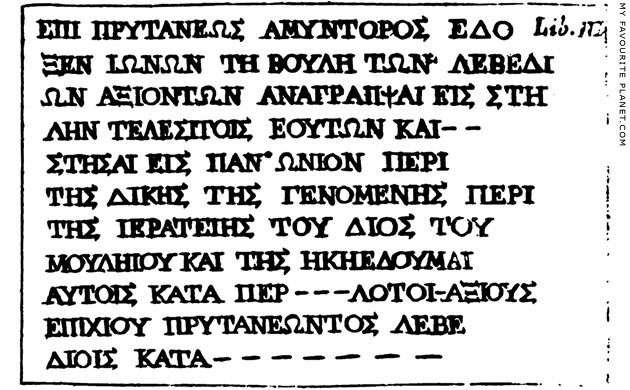
An ancient Greek inscription set up at Panionion. Seen on the wall of the church of
the Panagia (Virgin Mary) in Güzelcamli in 1673, and reproduced by George Wheler. |
| |
4. George Wheler on Panionion
The French doctor and antiquarian Jacob Spon (1647-1685) and the English botanist (and later clergyman) George Wheler (1650-1723) travelled together through Italy to Greece, Constantinople (Istanbul) and Anatolia in 1675-1676. Using Smyrna (Izmir) as a base, they visited several ancient sites in the area, including Ephesus, but were only able to stay there for one and a half days due to the threat of bandits, and were unable to travel further south.
In his account of their journey, Wheler related the report of a group of European merchants who in 1673 had travelled along the Ionian coast, through Scala Nova (Kuşadası) and Changlee (Güzelçamlı), and on to the valley of the Maeander river.
"Hence I shall take for my guide, an account given me of a journey made by Dr Pickering, Mr Salter, and several other merchants, there begun June 23, 1673 ...
... Wednesday, the third day of their journey, they set out about four in the morning; and about twelve came to a Greek village, called Changlee, situate by the sea-side, but almost ruined, having no defence against pirats; who in the time of the Venetian War, so infested this place, that now there remains only some few houses of very poor people; who are ready to run away, at the sight of every little bark they see at sea. They spent the afternoon there, by reason of a very high mountain they were to pass the next day; at the foot of which this village is situated; and rested in a fair and pleasant garden, full of oranges, limons, cherries, and several other sorts of fruits.
There are two churches here; one dedicated to the Virgin Mary; the other to St Katherin. On the wall of the first they found an inscription, where Amyntor, when he was prytane, or chief magistrate among them, ordered, that the worthy senate of the Ionians should cause to be written on a stone, and set up in Panionium, the result of their de
bates touching a law made, and justice done in the matter of the priesthood of jupiter Mouleius, etc.
Whence, I judge, the antient Name of this place was Panionium. That which confirms me in this opinion, is the situation Strabo gives to the Panionium, on this side of the Mountain Mycale, about a quarter of a mile from the sea: For so is the situation of Changlee. This Panionion was the place, where all these thirteen cities of Ionia met, to consult about their common affairs."
George Wheler, A journey into Greece in company of Dr Spon of Lyons, Book III, pages 267-268. William Cademan, Robert Kettlewell, and Awnsham Churchill, London, 1682. At Googlebooks.
Read more about Spon and Wheler on Athens Acropolis gallery page 12.
Dr Benjamin Pickering, a doctor of Levant Company in Smyrna, and Jerome Salter, a factor (merchant) of the company, are known from other contemporary sources. They had accompanied Spon and Wheler on an excursion from Smyrna to Brusa (Bursa, ancient Prousa, Προύσα). Salter made several drawings on his travels and some were used in Wheler's book. The drawing of the inscription in Güzelcamli may also have been made by Salter. His unpublished journal A brief relation of the travels of Jerom Salter is in the Bodleian Library, Oxford, and other related documents are in the British Museum.
For those interested in this aspect of Anatolian history, here are a few starting points:
F. W. Hasluck, Notes on manuscripts in the British Museum relating to Levant geography and travel, in The Annual of the British School at Athens, Volume 12 (1905/1906), pages 196-215. At the Internet Archive.
James Theodore, Early voyages and travels in the Levant. Hakluyt Society, London, 1893. At the Internet Archive.
Alan Cadwallader, The Reverend Dr. John Luke and the Churches of Chonai, in Greek, Roman, and Byzantine Studies (GRBS), 48 (2008), pages 319-338. At Duke University Libraries.
5. Hans Lohmann on Panionion
See:
Hans Lohmann, Survey of Mykale (Dilek Dağlari), 3rd campaign: Discovery of the Archaic Panionion (PDF document)
Wo der Stier brüllte: RUB-Archäologen entdecken das Panionion. Sensationeller Fund des antiken Heiligtums im Mykale-Gebirge. Ruhr-Universität Bochum press release Nr. 306, 20.10.2004. In German. |
|
|
Photos, maps and articles: © David John 2003-2019,
except where otherwise specified.
All photos and articles are copyright protected.
Images and materials by other authors
have been attributed where applicable.
Please do not use these photos or articles without permission.
If you are interested in using any of the photos for your website,
publication or project, please get in contact.
Higher resolution versions are available on request.
Some of the information and photos in this guide to Samos
originally appeared in 2003-2004 on davidjohnberlin.de.
My Favourite Planet makes great efforts to provide
comprehensive and accurate information across this website.
However, we can take no responsibility for inaccuracies or changes
made by providers of services mentioned on these pages. |
| |
 |
Visit the My Favourite Planet Group on Facebook.
Join the group, write a message or comment,
post photos and videos, start a discussion... |
|
|
| |
|
|
 |
| |
 |
| |
 |
| |
 |
| |
 |
| |
 |
| |
George Alvanos
rooms in
Kavala's historic Panagia District
Anthemiou 35,
Kavala, Greece
kavalarooms.gr
|
| |
Olive Garden Restaurant
Kastellorizo,
Greece
+30 22460 49 109
kastellorizo.de
|
| |
Papoutsis
Travel Agency
Kastellorizo,
Greece
+30 22460 49 286
greeklodgings.gr
|
| |
|